Sunday, March 24, 2013

New Zedland trip: Animals and ocean

Mountains are great. After a while of wow-ing at mountain after mountain, though, one starts wanting something a bit more relaxed...

...like some cows by the sea:

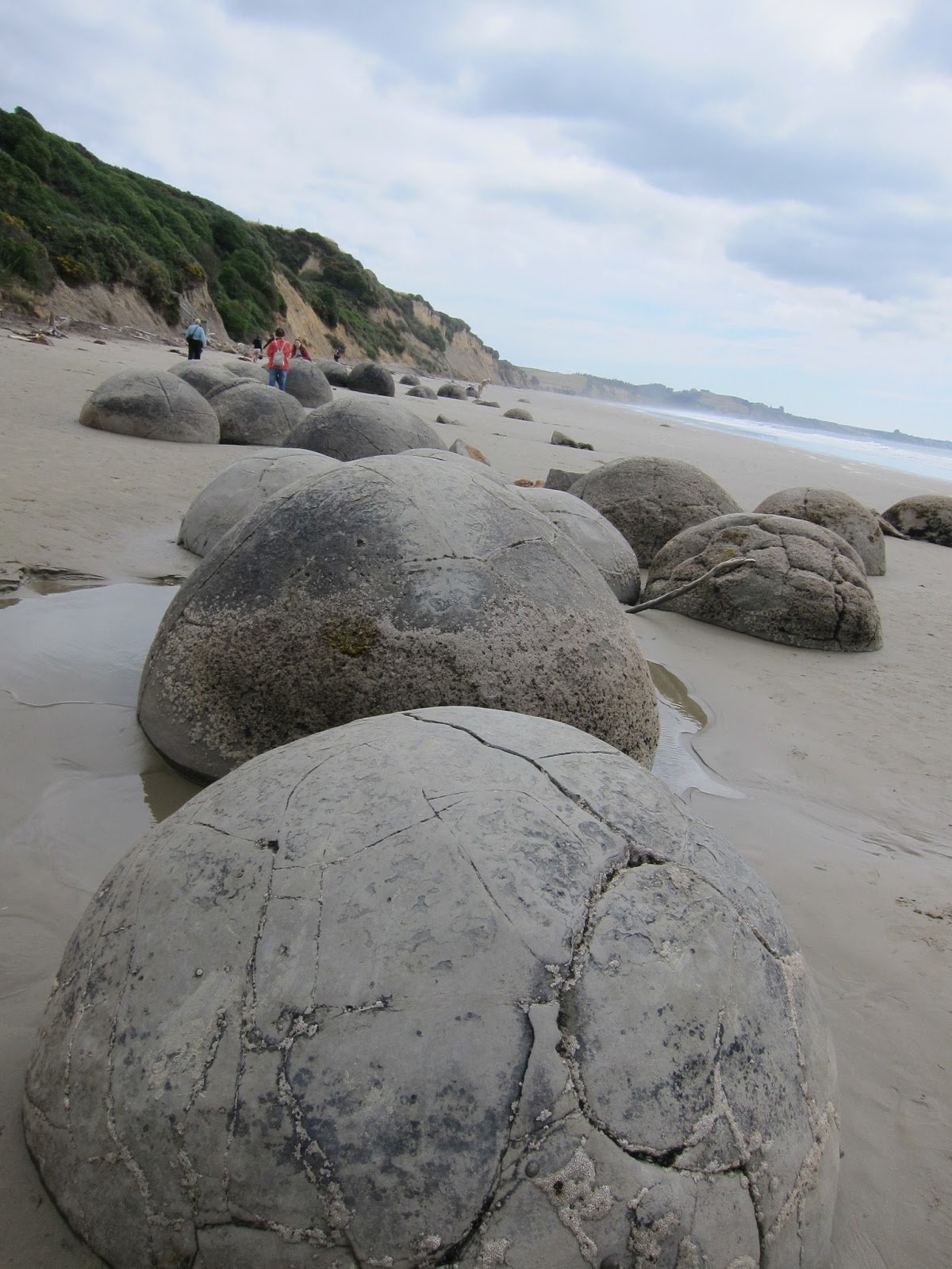
...or some weird round rocks on a beach:


So this post will be about scenes of animals and ocean-related scenes. We'll start with the native wildlife. 

Glowworms in the forest

Our first night, we walked out into the forest (on a fairly) well-marked path to see glowworms. They looked like this:

If that's not impressive, turn off all the lights and then imagine you're in a strange forest in the mountains.

The glowworms' spot wasn't especially interesting in the daylight - just some bushes. If we'd been glowworms, we would have lived in a spot like this (which we walked by a few days later):


Birds


Unfortunately, we didn't see any kiwi birds... though they're apparently pretty reclusive. Nor, more surprisingly, did we see any kea - a mountain parrot that is not remotely reclusive.

But we did see this:
It's not a duck - the beak was too pointy.

We also saw this gull (who clearly has a taste for lighting) eating a crab:


The real excitement, though, was penguin-spotting. This is a yellow-eyed penguin we saw on the south coast:

The landscape here is significant - we'll talk about that later.


Seals and sea lions

The only native mammals in New Zealand are sea-related: either sea-ls, or sea-lions.

In Milford sound, we got to see seals hanging out on a rock:

Very cute.

Sea lions are less cute. We saw some in a couple spots, though there were signs warning one not to get too close - the recommended minimum distance was 10 meters.

Here's what we think are a parent and child:

The vast majority of animals we saw, though, were non-native. Normally, they wouldn't be photo-worthy, but with the right setting...

Non-human European mammal invaders: Sheep, cows, and hedgehogs

We learned that sheep farming is declining in NZ, due to less demand for wool. Many farmers are switching to cows.

But we didn't have any shortage of sheep. We even got to have the road blocked by them:

Most of the sheep we saw weren't on the move, though. They seemed to just be posing.

There were sheep of the mist:

Sheep of the lighthouse (that little thing in the middle):


And sheep of the mountains:


Cows were most places sheep were - we didn't see any obvious pattern about who went where. These cows are across the road from some rock art that we'll return to in a later post:


The biggest surprise was a hedgehog:

The internet tells us that they were introduced in the late 1800's to control garden pests. That plan, as usual, didn't work, and now they're wiping out lots of native species. But they're still awfully cute...


We'll finish with some sea-related landscapes.


Pancake rocks

On our second day, we took a detour north to see the 'pancake rocks' - so-called because (with some creative imagining), they look like stacks of pancakes.

Funky. This was where we saw the brown bird that wasn't a duck.


Trees by the sea

By the pancake rocks (and along most of the west coast) were these Nikau Palm trees. They seemed very self confident, like a new toothbrush:

These were wind-swept trees a bit to the south:


Scenes from the Catlins

The Catlins area covers most of the southern coast. It doesn't get as much attention as the western coast, since it's less mountain-y. But we loved it. It felt a bit like the end of the earth - it was the furthest south either of us had ever been:


Below, in fact, is the southernmost point in New Zealand. You can see that our shadows made it a bit further south than we did (the cliffs were crumbly):


Here is a petrified forest in the sea - you can still see the shapes of logs. This was where the above penguin made his/her appearance. Good taste:

One of the our favorite spots was a set of sea caves that can only be visited for about 4 hours during low tide. We were lucky enough to get the timing right. Here's a view looking out:

A view looking in:

And the view of Colin walking casually by:

The most dramatic spot, though, was called 'Nugget Point.' The point was at the end of a steep ridge, with mist racing up the side:


This is the view from the end - those rocks vanishing into the mists are the 'nuggets':

To round out this post - a classic sunset shot. We were lucky enough to catch this sunset - just the right mix of seamist and late light:

Next post: human civilisation....


Friday, March 15, 2013

New Zedland trip: Water (and more Mountains)

When we move to Seattle, we'll have a bit more water in our lives. Part of what makes New Zealand's mountains so incredible is how they're set next to the ocean, lakes, waterfalls, rivers, glaciers, and fiords.

Here are some of our favorite water-related scenes (minus beach-y scenes, which we'll have in the next post).

Lake Matheson

Near the town of Fox Glacier, where we stayed for our second night, is a lake that is known for how it reflects the mountains. We were told to get there early, before the clouds moved in.

Our luck was fantastic:

 The mist was just rising from the lake as we approached.

The lake was almost a perfect mirror... with some lingering mist for extra effect.


That tall thing is Aoraki/Mt. Cook, the highest mountain in New Zealand. Later, we'll see it from the other side. But this view (which they named "the view of views") was unbelievable... even worth sharing the path with a bus-load of British teenagers.


Glaciers


The snow you see on those mountains feeds into glaciers. There are two glaciers that are especially easy to visit: Franz Josef Glacier and Fox Glacier.

We came to Franz Josef first. The valley felt like something from some other era - not for the last time, it felt like the laws of physics had been changed just a bit:


For safety reasons, we couldn't get too close, but the walk up the valley was stunning. A stone-grey stream came out from under the glacier:


Our weather luck was better with Fox Glacier, and the safe path allowed us to get much closer. A huge river of ice, with ice-valleys instead of waves:

As the glacier moves along, rocks and dirt fall on top of it (since it's carving out the valley). Here you can see part of the edge, along with some helpful signs about why one shouldn't run up to touch it:

 This was the view back down the valley. You can see how, when the glacier went further, it carved almost vertical cliffs:
 
Waterfalls

The waterfalls we saw tended to be dwarfed by other parts of the scene, but were still striking. (Despite being less dramatic than at other times of the year, since it had been a particularly dry summer). Here's one in the Franz Josef valley:


The next is, according to our guidebook, one of the most photographed waterfalls in the world (whatever that means). We hereby add one more:


The closest we got to a waterfall was this one:


This waterfall goes directly into Milford Sound. This view was from a boat. Speaking of which...


Milford Sound


Milford Sound may be the main tourist destination on the South Island. Turns out there is good reason for that. One approaches by road (see our previous posts), eventually ending up at the edge of the water:


The best way to see the Sound (which is actually a fjord) is by boat. We got some advice about dodging the main rush of tourists, and had a pretty comfortable ride on the red boat here:

If we'd had more time, we would have done a kayak tour, but what we saw was still pretty amazing.


Heading out towards the sea, here's a more distant view of the waterfall from above:
The waterfall is at the point where two glaciers once met.

Another view on the way out:

At the mouth of the fiord is the Tasman Sea (if you kept going in this direction, you'd get to Australia):

We then turned around and headed back inland:

We could have also done a scenic plane ride. We opted out of that, but Naomi caught this shot:

Lakes

The mountain range forms a pretty effective rain barrier. Not far from the above, one suddenly finds dry mountains and stunningly blue skies:

This is near Queenstown (more on that later). 


Later in our trip, we headed back towards Aoraki/Mt. Cook from the east. Here you can see it across Lake Punakaki:


The water really is that color. We read that it's due to some sediment that reflects light in a certain way. Our last night was spent next to the lake just near it, Lake Tekapo (which had a similar sediment-light effect). Here are some other visitors we saw:


And one more shot, bringing out the bizarre color:

Next time: Animals, beaches, and forest (and sun)!

Friday, March 8, 2013

New Zedland trip: The mountains

We recently returned from a journey to the south island of New Zealand. The scenery lived up to the quote on the back of our Lonely Planet guide: "New Zealand is jaw-droppingly gorgeous. The word 'Wow!' will escape from your lips at least once a day."

We went well over our once-a-day 'Wow!' quota. 

Peter Jackson's decision to complete the 3 hobbit movies now makes a lot more sense: the Lord of the Rings movies barely touched on the varieties of amazing settings we saw in just 9 days. We took around 1500 photos, so it was a difficult task to choose just some to put on the blog. So, we decided to make a few posts each with its own theme. 

If you would like a sense of where we went, you can see our route on this map.

We'll keep our words brief. Just imagine everything in the pictures being much more towering than it seems.

The topic of this post is: Mountains. There were lots of them. And they were hard to fully capture in photographs, but we tried. 

On the approach to our first destination in Arthur's Pass:

If you look closely, you can see the red-flowering rata (a type of tree) halfway up this mountain. Apparently we came at the right time of year to see them.

The mountains we saw after Arthur's Pass were unmarked (no special look-outs, no signs, etc.). Like they were no big deal. But they were still stunningly beautiful:

One of our goals on the west coast of NZ was to see glaciers. More on those next time. But here's a teaser shot of the mountains on the approach to Fox Glacier:

On a clear day, one can see Mt. Cook from near Fox Glacier. We had great weather luck (though apparently NZ is having a drought now). Here's the tallest mountain on the island... from a very long ways away:
This was only our first view of mighty Cook. It reappeared at various other points along the trip.

After a couple days on the west coast (more about that soon), we headed inland again, via Haast Pass. More outrageously amazing mountains, this time with a river and low clouds:

The mountains continue inland, in a drier way. This is part of a range called 'The Remarkables' near Queenstown.

One of the best-known destinations on the south island is a fjord called 'Milford Sound.' We liked the Sound (fjord), but liked the drive there at least as much:

There were lots of places to stop on the road. One of our hosts had recommended one hike in particular, at a place called 'Gertrude Saddle.' The rock was a sort of silvery granite, and the hike led us straight into a valley with sheer rock walls with bits of forest, alpine shrubs, and waterfalls.

A view of the approach, with some Germans for perspective:

Looking in the opposite direction:

Up closer, on an ascent, with Naomi for perspective:

The view from our lunch spot, with feet for perspective:


And here's a final glance as we looked back while returning. The shrubs were different from anything we've seen before:

After the hike, we went through a tunnel into the Milford Valley. Here are two views of that:


Wow wow wow.

Stay tuned for glaciers, lakes, rivers... and more mountains (of course).

Sunday, January 6, 2013

5 photos from Melbourne summer

Happy 2013, everyone!

For those up north in the grip of winter, here are a few warm scenes from Melbourne.

The sun sets over the bay on the solstice:


The Mornington Peninsula on Boxing Day:


Kite-surfers on the first Sunday of 2013:


Last, here's a piece of street art that appeared a while ago near us. Warm weather makes it easier to stand around and appreciate such things: